Mt. Williwaw Northwest Ridge/The Ramp from Glen Alps
Get link
Facebook
X
Pinterest
Email
Other Apps
Mt. Williwaw Northwest Ridge/The Ramp from Glen Alps - 5:46:27
This was Plan B of the day. The original plan was to finally go and conquer Eagle Peak, but when the forecast called for rain, well, such a long day didn't sound fun at all. So I opted to try and summit Williwaw via one of the more difficult routes.
Walking across the Ballfield
Black Lake hidden below the north face of O'Malley
I knew that the chance for rain was supposed to increase toward noon, so I set a brisk pace up Little O'Malley, across the ballfield, and up again to the west buttress of Williwaw. Those rocks wouldn't be fun in the rain!
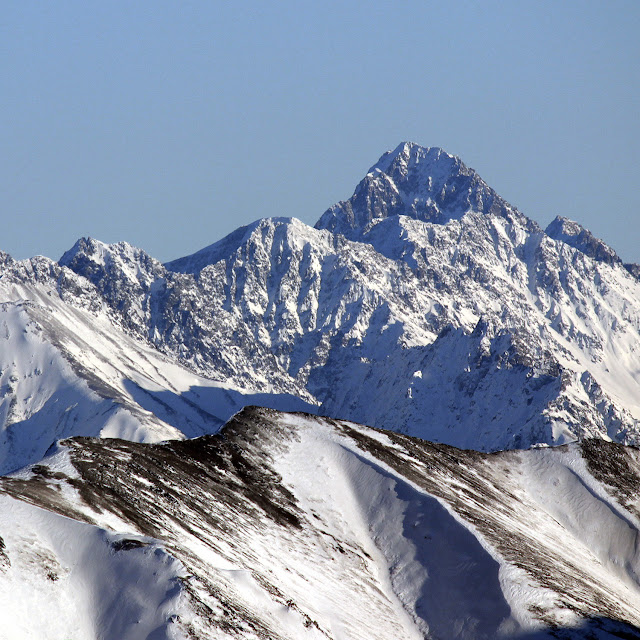
The Williwaw "pyramid" as seen from the west buttress. The Northwest ridge is on the left of the pyramid.
At the bottom of the route. Nice scrambling ahead! Just make sure to hit it in the dry!
Having literally just been here a little while ago with my cousin, I knew exactly where to go and how to do it quickly, so pretty soon I was where we had turned back just a few days ago.
Lots of exposure to be had, but on stable-ish rock. Tread carefully!
Confident in the dry. Just don't look down.
Conditions were dry. And warm. I kept my gloves off, and having the extra confidence of bare fingers was welcoming. Since I was by myself and without gear, I did skirt around two of the more imposing gendarmes. This made the ascent a lot easier than I was expecting! I reached the top of the ridge and the summit of Williwaw in under 3 hours.
OK fine, I admit it. I'm a sucker for fast summit times.
Once on the summit, I decided that instead of going back the traditional way up the Ballfield, I'd rather have a pleasant traverse toward the ramp and descend that way. Much nicer!
Typical travel on the ridge to The Ramp
Looking back towards Williwaw
So I took it easy on the way back, and had quite a nice return journey via the hidden lake trail.
Overall, it was an AWESOME alternative to the much further off Eagle, but the weather remained so nice that I almost regret my decision to forego it...
Down down down to the powerline
Heading down towards Hidden Lake. I admit I drank some of this.
Told you I drank some of this!
Williwaw NW Ridge Route Info
As Bill Finley has mentioned, the rock is stable for Chugach choss. That being said - it is also very exposed and stability is a relative term. If you're not familiar with this type rock, I would travel slow and DEFINITELY bring some gear. Heck, even if you are confident and experienced in the Chugach, I would suggest gear, especially if it's wet (BTW I'm pretty stupid for not doing so). The hardest parts are avoidable, but if it gets moist, the mossy rock is not friendly. All of that aside: I highly recommend this way up Williwaw - it may be the fastest way!
Skybuster/Ice Cream Cone seen from Mt. Significant, January 2019. LONG lens! I remember the first time I saw it. Eastbound on the Glenn, just before passing Kings Mountain and Chickaloon, on a clear, flat section of road, I happened to glance south, and there it was, standing tall in the distance. I couldn't take my eyes off, and couldn't help but wonder: did that insane tower of rock have a name, and what would it be like to stand on its incredible, precipitous summit? Since I wasn't driving, I easily answered the first question with Google. That inspirational behemoth was named Skybuster. Answering the second question, however, would have to wait. Several years and lots of beta gathering later, it was time to try. Since the peak is so remote, it seemed a good idea to make this our first fly in approach. With excitement and some apprehension, we loaded up at Merrill field and flew (choppered!) out. WOCKA WOCKA WOCKA Sitting in t...
Total Time - Just about 9.5 hours. 46 minutes biking in, 7:59:37 hiking, 46 mins biking out. Civic DX ready to roll! I left my house at 5:30 and was riding around Eklutna by 6:20. There was a lot of bear crap on the trail, so I did some extra "hey bear!" in addition to my two bearbells. After 10 miles, it was time to ditch the bike - but what was this? There were already some people here! A group of two declared their intention to climb Bold, and there was a group of three trying Bashful! Riding around the lake Trusty 9:ZERO:7 Whiteout with Bashful above! The two were still busy with gear, so I started walking with the trio, glad to have some company for what I had anticipated to be a very spooky (bear-ie) walk to Stiver's. Once we arrived, I bade farewell to the group and went on ahead. My Bashful Buds :) Things went great until I took a very ill-advised wrong turn, and ended up missing the alder tu...
Granite Peak Southwest Ridge - 3rd Time's the Charm! 5.8 miles/2.7k gain to base of peak 2.2 miles/3.4k gain on the actual peak To put it mildly, this mountain has been elusive. My first attempt saw me high on the peak, reaching the top of a gendarme, only to see a thunderstorm quickly bearing down. Knowing how much fun mountain thunderstorms are (not), I turned back without hesitation. The second try was more of a long shot - the weather was wet and socked in, and the mountain had some early snow. No thanks. I'd often wondered if I wanted to bother with a third try on Granite, but the promise of a long bike downhill sealed the deal (you can hike too, but it's less fun...) By 7 am on July 4th, I was driving toward Eska Falls. Depending on what sort of vehicle you have, you may find yourself parking well before the real Eska trail begins. My Corolla isn't much of an offroader, so I a...


Comments
Post a Comment