Posts

Showing posts with the label Chugach

Ice Cream Cone/Skybuster Mountain 8/22/20

Image
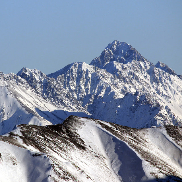
Skybuster/Ice Cream Cone seen from Mt. Significant, January 2019.  LONG lens!    I remember the first time I saw it. Eastbound on the Glenn, just before passing Kings Mountain and Chickaloon, on a clear, flat section of road, I happened to glance south, and there it was, standing tall in the distance. I couldn't take my eyes off, and couldn't help but wonder: did that insane tower of rock have a name, and what would it be like to stand on its incredible, precipitous summit? Since I wasn't driving, I easily answered the first question with Google.    That inspirational behemoth was named Skybuster.    Answering the second question, however, would have to wait.    Several years and lots of beta gathering later, it was time to try. Since the peak is so remote, it seemed a good idea to make this our first fly in approach. With excitement and some apprehension, we loaded up at Merrill field and flew (choppered!) out. WOCKA WOCKA WOCKA Sitting in t...

Troublemint Peak Southeast Ridge 6/25/2019

Image
Troublemint Southeast Ridge  20.66 Miles / 10:16:38 / 5950ft gain     T his was one of those days where I remained indecisive 'til the very end - I wanted an easy approach, no shwack, and something I hadn't climbed before. Hurdy Gurdy seemed like a good idea, but when the day dawned with plenty of smokey haze from the Kenai wildfire, I decided to set my sights further north.    I figured I'd try one of the Mint peaks. The approach, Gold Mint trail, fit the bill as an easy, runnable approach, and the distance from the Kenai (hopefully) meant less smoke. The problem was which peak? After a quick look at Peakbagger, I decided to aim for Troublemint... Although the truth was, I didn't mind climbing whatever seemed possible and appealing upon seeing it.    I was on the trail and running towards Mint Hut just before 7am. The brush was remarkably dry, and miles passed quickly and pleasantly. Visibility was awesome, and I had a few good glimpses o...

Mt. Rumble - Lettssss get ready to RUMBLEE!!

Image
Mt. Rumble 7530' 22.6  miles/11900 ft/11.5 hours Descending toward Mt. Rumble.    This was an absolute WHOPPER of a day - the most elevation gain I've ever done! Weather was nothing short of breathtaking the entire time.  I even nailed the route dead on, except for some fumbling around on the rock glacier/Bombardment pass.    Traveling over Bombardment Pass on the way in, I thought it would be a good idea to get onto the ice/snow right under Korohusk. Well, yes, that would've been a good idea... With spikes! I had nothing, so I went full caveman and used a sharp rock to chop steps for myself.    It took me just over two hours from the Peter's Creek crossing to the summit of Rumble. The gully was an absolute slog, and the 4th class step out of it would have been far more interesting in wet weather. There's algae on them rocks!    Coming back over Bombardment was the real test. I was totally worked by the second time I came over...

Sunny FRange love - North Suicide North Ridge, Homicide Northwest Ridge

Image
Sunny FRange  love!  10 Miles/6500ft/8.5 hours on foot    Yesterday's sun created a dilemma for me - stay close to Anchorage and link up some peaks, or head further afield and bag a single, large peak.  Well, I've done my share of big peak bushwacking this summer, and I'm getting a bit sick of being soaking wet before even being ON the mountain.  Easy choice.  Front range, here I come!    I parked at Glen Alps, and was on my bike heading toward the Powerline pass by 8AM.  It seems that nature has a cruel sense of humor, 'cause I only made it a few miles before I ran into several bull moose sleeping on the edge of the trail.  Bushwack time!  Goodbye, dry feet!  (they remained moist for the rest of the day).    After passing Ptarmigan Peak and crossing the creek west of Green Lake, I ditched the bike and began hiking up the north ridge/side of Hope Mountain.  This ridge was fairly easygoing, with a...