Thursday, July 16, 2015

Williwaw South Ridge

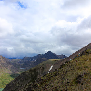
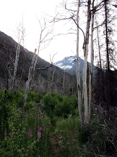
Arrived at Glen Alps about 8:30.  Was the ONLY car at the second lot.  Woohoo!  Kinda shuffled/ran the first mile past powerlines and towards little O'Malley.  When the going got steep, slowed it down and "power hiked".

Did some more shuffle running through the ballfield.  I guess I think of the ballfield as junk miles before getting wherever you're going...

And here's where I was going: 

MOUNT WILLIWAW!


The picture is from the east end of the ballfield - right before dropping down into the valley that contains the Williwaw lakes.

Slid down on some handy scree.  Stopped to empty shoe rocks.

Continued on towards the west buttress of Williwaw, staying right-ish to funnel into the south ridge route.  Thought clouds were gonna start filling in, but it stayed only partly cloudy.  Whew!


I went up the rocks that are to the right of the snow in the center of the picture.  There's a definite RIGHT way through - go too far right or too far left and you're in for some nasty exposure.  Once you're past this though, it's an easy scramble up the final bits of the south ridge:


And you're at the top!  


It took me just under 3 hours to reach the top.  Stopped for a lunch break, then left at exactly the 3 hour total mark.  Made it back to Glen Alps at around 6 hours.  GPS data:


15 miles, 5,937 feet gain, 5:55 total time, 5:17 moving time, avg moving pace 21:11

No real running, just brisk hiking.  Melted those miles away!  


Wednesday, July 1, 2015

Bashful Peak Abort @ 7K feet with Andrew

It was an early, EARLY start for us.  We loaded the Nissan with our trusty "hike bikes" and were rolling towards Eklutna by 5:30AM.

Excitement ran high.  Drew and I had read a lot about Bashful, and although it sounded like a fairly adventurous undertaking, we had complete confidence of reaching the summit with minimal mishap.

Arrived at Eklutna lake.  Unloaded beater bikes.  Riding at 6:36AM.

We knew that it was about 11 miles of gravel grinding until hitting the East Fork trail, which is where we would ditch our bikes and begin the REAL hike.

The first miles passed a bit chilly, but we soon forgot about the cold altogether as we entered the realm of  the largest peaks western Chugach has to offer.
  
As we came to East Fork and prepared to leave the bikes, we got a good look at the south ridge of Bashful:


We strolled along the river, passing through what I can only describe as "fairytale forest"


The grass and trees closed in the further we went, making me glad to have a bearbell.  I couldn't help thinking of this line from Jurassic Park, and it got stuck in my head for a good half hour:
 

After about 2 3/4 miles, we noticed some cairns to the left of the trail.  Stiver's Gully!  The gateway to Bold and Bashful!  We followed...  Quite a bushwack at first, and I was terrified that if this was the beginning of the Bold trail, then it would be quite easy to miss the turnoff for less-popular Bashful...  

Eventually it cleared out though, and right before the start of the gully proper, we noticed the Bashful trail and cairns to the right.  Nice!  

The first 1000ft  or so of vertical came with nice prickly grass steps and small dusty chutes.  We were soon shunted off to the right and into some Alder thickets and the dreaded "Alder Tunnel".  Once above the tunnel, the views were GOOD!  

I decided to make a little cairn at the top of the tunnel - just in case!  


From here, we went up a nice meadow, through another thicket, and came to see this:


Scree and grass up to 3000-3200!  We went up the grass and into the middle chute.  Those rocks were bigger than they looked!  

From here we had a pretty easy time all the way to 5000 feet.  It was nice, grippy grass.  At 5k, the grass disappeared and we got a taste of scree and rock.  Leaning rock at 5k:


From here, the going got a bit slower and clouds started to thicken.  We could see the summit of Bold was started to get covered.  Uhoh...  

Right at about 7k, it started to snow, and we ran into this little number:


Now, I knew a gully high on Bashful had been lovingly christened "Chickensh*t", so I assumed this was it.  We stopped here to think about it, and put on warmer clothes.  I downed a PB sandwhich and we assessed our situation:


We were convinced it was indeed the infamous gully, and we knew that there was no way around it then.  As time went on and we got colder, the idea of trying our way up seemed less and less interesting.  Besides, what would we see at the summit, and how would it be downclimbing once we were even colder?  Ugh.  Our decision to turn back was pretty easy.  

It snowed all the way to about 5k feet, and due to the visibility, we had to constantly fight against being shunted east.  Once things cleared up and we were lower, it was much easier.  

At the 3000 foot mark, we had a bit of a snafu trying to recall exactly which chute we came up, but luckily we had noticed some landmarks on the way up and soon sorted ourselves out.

We went through the tunnel and the fairytale woods without incident, bear or otherwise.  Weather was great down here.  It was a strange feeling - getting back on the bikes, waiting for our first sighting of other humans in such a long time.  I can't imagine being away from people for weeks...  Not that it would be a BAD thing, just odd feeling.  

During our ride back, some guys in a side by side utility vehicle stopped and chatted with Drew about our hike.  It was kind of obvious they had no idea what peak we were talking about, but it seemed they had an inkling that it was some sort of serious venture...  

The last mile came, and we arrived back at Max the Maxima!  The bikes were drastically dustier than they had been beforehand:


So we loaded up and drove on back to ANC - not triumphant, but not unhappy either.  I'll probably have another crack at Bashful this fall.    

Further stuff 

GPS Data from Garmin 310XT:


Video from Andrew's GoPro, starting where we turned back


Also I have come to realize that the gully we found wasn't Chickensh*t, but rather a different nasty bit on the way to Chickensh*t.  Oh well.  Probably good we turned back when we did.