I had several goals with this hike: enjoy a sunny (for once) day off, keep it short to keep my IT band happy, and test out my chest mounted gimbal on a scramble. Sounds like a job for East Twin!
Obligatory Civic shot with the Twins lurking in the background
I'd climbed West Twin a few weeks ago and was quite pleased with how short the approach is. Basically, you just park at Eklutna, head up the Twin Peaks Trail, pass one bench, pass another, and boom - just head over to the Twins. Easy peasy!
View from bench numero uno. Bold is back there - in the cloud.
The twins coming into view on the way to bench two.
Bench two. Take the trail on the right to climb Pepper Peak.
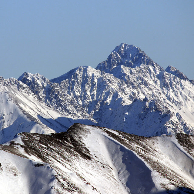
Stream crossing and East Twinny.
Oooohhh ahhhh it's getting nicer!
The standard route for East Twin follows the south gully, and this is where I headed, noting that it wasn't really as great of a day as promised... In fact, there were a few raindrops! Some slices of blue sky began to develop as I climbed toward the gully, and eventually, the blue did take over the majority of the sky. Nice.
Looking behind me as I climb - blue skies starting to take over
Down towards Eklutna
Fiery fall colors
Passing some wary sheep, I reached the gully and began to scramble up. And quite scrambly it was! Lots of loose rock - I hugged the sides to get better grip. A few steeper sections but nothing outrageous. I was heavily reminded of the south gully on Eagle Peak. Same thing here, just a heck of a lot shorter.
The wary sheep.
Scramblins
Eventually, I reached some cairns that led right or left. I didn't know what to make of these, so I decided to just keep going up the gully. In hindsight I now know that these lead to more solid (if exposed) routes to the summit. Oh well! Next time.
More scramblins
It was getting quite windy, as all the wind was being funnelled through the narrowing gully. Quite a chilly wind too! I was a bit upset that I didn't bring the wind covers for my thin gloves. Finally, at the end of the gully, is a very narrow slot. Past this slot, the wind was blocked. Whew. It felt good to get out of that. It was just a few minutes of easy scrambling to the summit.
The summit was windy too of course, so I only spent a few minutes before heading down. I did get a good view of the other Twin, Pioneer, Bold (which had a lot of new snow) and the very menacing looking Goat Rock. After some pictures and video, I went down.
Remember when I said I was a sucker for fast summit times? My version of signing the register.
Pioneer Peak
Pioneer on the left, Bold on the right.
More Bold and Eklutna.
West Twin and Goat Rock. WTF Goat Rock looks dang intensseeee.
My poor hands were basically bricks for a while, thanks to my forgetfulness of the wind shells. Once I got lower and out of the gully, they did warm up, but not without a good deal of pain.
The way back down was uneventful. I stopped at Eklutna to get several photos of Bold. The day had an iffy start, but pulled a 180 and was now beautiful. Overall, an excellent peak for those days when you want something more brief :)
Skybuster/Ice Cream Cone seen from Mt. Significant, January 2019. LONG lens! I remember the first time I saw it. Eastbound on the Glenn, just before passing Kings Mountain and Chickaloon, on a clear, flat section of road, I happened to glance south, and there it was, standing tall in the distance. I couldn't take my eyes off, and couldn't help but wonder: did that insane tower of rock have a name, and what would it be like to stand on its incredible, precipitous summit? Since I wasn't driving, I easily answered the first question with Google. That inspirational behemoth was named Skybuster. Answering the second question, however, would have to wait. Several years and lots of beta gathering later, it was time to try. Since the peak is so remote, it seemed a good idea to make this our first fly in approach. With excitement and some apprehension, we loaded up at Merrill field and flew (choppered!) out. WOCKA WOCKA WOCKA Sitting in t...
Granite Peak Southwest Ridge - 3rd Time's the Charm! 5.8 miles/2.7k gain to base of peak 2.2 miles/3.4k gain on the actual peak To put it mildly, this mountain has been elusive. My first attempt saw me high on the peak, reaching the top of a gendarme, only to see a thunderstorm quickly bearing down. Knowing how much fun mountain thunderstorms are (not), I turned back without hesitation. The second try was more of a long shot - the weather was wet and socked in, and the mountain had some early snow. No thanks. I'd often wondered if I wanted to bother with a third try on Granite, but the promise of a long bike downhill sealed the deal (you can hike too, but it's less fun...) By 7 am on July 4th, I was driving toward Eska Falls. Depending on what sort of vehicle you have, you may find yourself parking well before the real Eska trail begins. My Corolla isn't much of an offroader, so I a...
Ridge conditions November 2018. Point 3920 on left, Indianhouse NW ridge on right. I 'd attempted this ridge last November, but a late start and general unpreparedness saw me turning back at the first gendarme. I vowed to return, and almost exactly a year later, I found myself parked at Fall's Creek and hiking up point 3920. This time, it was 8am, and I had ice tools and a rope. Top of 3920, looking towards Indianhouse. First gendarme is center left. R eaching the top of point 3920, I clipped on crampons and took out the tools. After descending to the ridge proper, I quickly made my way to the top of that first gendarme, encountering light mixed climbing on the way up. At the top, I surveyed the options. A rappel was pretty much mandatory from here - downclimbing would have been nutty and I had, after all, lugged 60m of 9.4 all this way... Maybe I need to invest in a lighter rope ;) Using the tools...


Comments
Post a Comment