Skybuster/Ice Cream Cone seen from Mt. Significant, January 2019. LONG lens!
I remember the first time I saw it. Eastbound on the Glenn, just before passing Kings Mountain and Chickaloon, on a clear, flat section of road, I happened to glance south, and there it was, standing tall in the distance. I couldn't take my eyes off, and couldn't help but wonder: did that insane tower of rock have a name, and what would it be like to stand on its incredible, precipitous summit? Since I wasn't driving, I easily answered the first question with Google.
That inspirational behemoth was named Skybuster.
Answering the second question, however, would have to wait.
Several years and lots of beta gathering later, it was time to try. Since the peak is so remote, it seemed a good idea to make this our first fly in approach. With excitement and some apprehension, we loaded up at Merrill field and flew (choppered!) out.
WOCKA WOCKA WOCKA
Sitting in the chopper at Merrill field.
Fueling up in Palmer.
Cruising by the familiar landmarks of Vista, Twin Peaks and Pioneer was a surreal experience, yet nothing compared to the insanity of landing below the south face of Skybuster mere minutes after departing Anchorage. I swear it feels like it SHOULD have been more difficult. We waved farewell to our chopper buddies, and they were gone.
This would have been part of the human powered approach. Might've taken a while!
Chopper friends!
BYEEE!
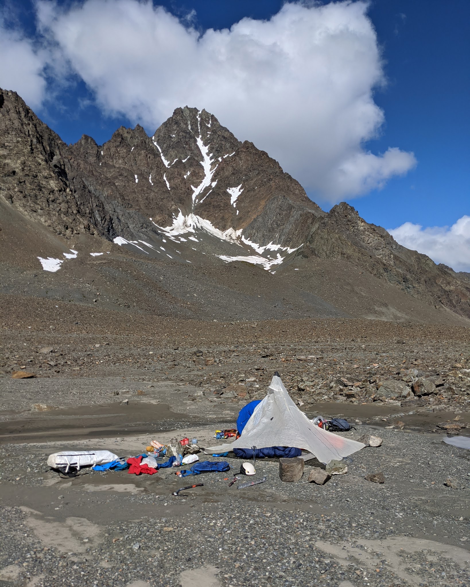
Since we arrived in the early afternoon, we had plenty of time to investigate our camp site and walk up to our intended route. Snow conditions were the biggest concern (followed by rockfall), but a brief investigation of the gully above proved more favorable than expected for both. The new concern was the narrowing of the upper section of gully - from below, it appeared a potential technical challenge, but was impossible to say for sure. We vowed to give it an early start tomorrow, and returned to camp for a good brew.
This was an amazingly perfect camp site.
Studying the route for tomorrow's attempt.
Ooooohhhhhh ahhhhh pano!
Some rain showers moved by throughout the night, but were interspersed with long periods of amazing star visibility. I propped my phone on my pillow and capitalized on this - I had long been waiting to try the Pixel 4 star photography. Seriously impressed with one of the shots I got.
Night sky. Amazing what a modern smartphone can do.
The following morning, we departed at first light and quickly french techniqued our way up the wide snow field at the bottom of the gully. After crossing several runnels (and encountering some nice WI therein) we came to the narrowing section we had worried about.
Trudging to the snow...
Trudging UP the snow
Finding WI!!
Gimme summa dat WI plz
As it turned out, the first step was easy mixed terrain, followed by several more steps of easy ice and snow, leading eventually to a wider gully with more snow. From here we gained the summit ridge.
Cody topping out on the (quite) easy mixed section
The rest of the narrow gully. Some ice up there that may just edge into WI2 territory, if I'm being generous ;)
I had heard a lot about this summit ridge and was expecting some srs bsns, but we found nothing worth roping up for. The rope stayed in the bag all the way to the summit.
Typical summit ridge. There was ONE gendarme that was easily dealt with.
The summit itself was a slightly anti-climactic mellow snowfield with a severe drop on the north side. Unfortunately, clouds had moved in and obscured our hopes of seeing far and wide into the Chugach, yet we did have a small break in the clouds looking northward. It was nice to get at least SOME views!
The Moistboyz, aka Krusher and co., aka Send Squad, aka Beavis and Butthead
The view to the north.
We descended in deteriorating weather (snowflakes!) and finally broke out the rope to rappel the mixed step. A slung horn with a bomber piton backup saw us down without trouble. As we descended the wider snowfield, we did see some random rockfall that hastened our downclimbing speed, yet we made it back to the tent without incident.
Through the magic of an early start, combined with a chopper drop at 5k feet, we realized we had finished way ahead of schedule - it was only 12pm. After some deliberation, we figured it best to try to leave early, given the questionable weather. A quick InReach text later and the chopper was on its way back for us.
Things were starting to look a bit worse down here. The rain was soon to follow.
As we waited for the WOCKA WOCKA, we packed up camp and wondered at the strange weather. Several rock towers in the distance were being hidden by sheets of rain, and sure enough, the rain came our way and started drenching us with frigid wetness. Luckily, the chopper arrived not much later, and we thanked our pilot profusely for our "rescue".
Once again, it was a surreal flight back to Anchorage. One moment we were freezing, next moment we were in the sun at Merrill field. Big thanks to Kodiak Helicopters, our pilot Chris and his assistant Bridget. Super flexible flight plans, very professional and very affordable. I think I could get used to this!
Granite Peak Southwest Ridge - 3rd Time's the Charm! 5.8 miles/2.7k gain to base of peak 2.2 miles/3.4k gain on the actual peak To put it mildly, this mountain has been elusive. My first attempt saw me high on the peak, reaching the top of a gendarme, only to see a thunderstorm quickly bearing down. Knowing how much fun mountain thunderstorms are (not), I turned back without hesitation. The second try was more of a long shot - the weather was wet and socked in, and the mountain had some early snow. No thanks. I'd often wondered if I wanted to bother with a third try on Granite, but the promise of a long bike downhill sealed the deal (you can hike too, but it's less fun...) By 7 am on July 4th, I was driving toward Eska Falls. Depending on what sort of vehicle you have, you may find yourself parking well before the real Eska trail begins. My Corolla isn't much of an offroader, so I a...
Troublemint Southeast Ridge 20.66 Miles / 10:16:38 / 5950ft gain T his was one of those days where I remained indecisive 'til the very end - I wanted an easy approach, no shwack, and something I hadn't climbed before. Hurdy Gurdy seemed like a good idea, but when the day dawned with plenty of smokey haze from the Kenai wildfire, I decided to set my sights further north. I figured I'd try one of the Mint peaks. The approach, Gold Mint trail, fit the bill as an easy, runnable approach, and the distance from the Kenai (hopefully) meant less smoke. The problem was which peak? After a quick look at Peakbagger, I decided to aim for Troublemint... Although the truth was, I didn't mind climbing whatever seemed possible and appealing upon seeing it. I was on the trail and running towards Mint Hut just before 7am. The brush was remarkably dry, and miles passed quickly and pleasantly. Visibility was awesome, and I had a few good glimpses o...


OH YEAH
ReplyDeleteOHHHHHH YEAH
Delete