It was summer conditions all the way to the Eklutna campground, where I ditched the bike and set off on foot across a very moderately flowing river. I didn't even need to take my boots off - the water was less than ankle depth for most of the braids with a jump across one deeper section.
Riverbed in the foreground, Watchman north ridge in the background.
Once on the far side, I found an overgrown orange flagged trail, followed it for a while then went straight up brushy fields to gain the ridgeline.
It was easy travel on the ridge. Most of the snow had melted on east facing aspects, making crampons unneeded if sticking to the melt line. Eventually snow cover increased, so I donned gaiters for the inevitable deep snow encounters.
About midway through the ascent, the ridge dips down to a flatter bench. I didn't trust that traveling on this bench would turn out well, so I opted to regain the ridge. In retrospect I could have avoided several exposed sections by staying lower for longer, and regaining the ridge later on.
The ridgeline steadily became harder to negotiate, as the snow on the west side was deep and the rock on the east side was getting steeper. I still managed to avoid snow for the most part, but was thankful for the gaiters and ice ax when I did encounter it.
The summit block is essentially a narrowing of the ridge down to a very small point - a point that as I approached looked slightly threatening. As it was, by sticking to the interface of snow and rock, I had good handholds the whole way while kicking into the snow and then standing on top of the melted out rock. I'm not sure if the snow made it easier or harder, as summit photos of previous parties make the rock quality look quite poor.
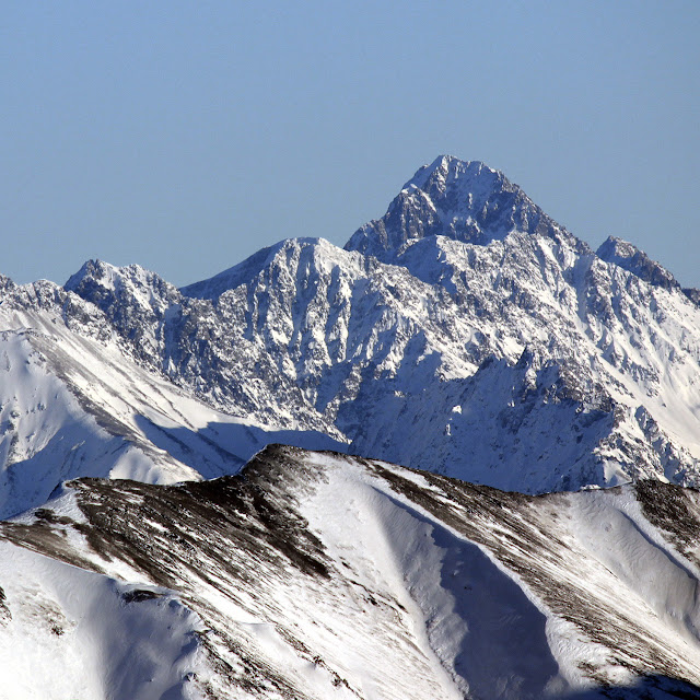
North ridge with summit block ahead. This was in fact looking back while on the way down - you can see my footprints if you look closely.
Looking at the summit register, I was surprised just how few people visit this peak - the last recorded ascent was in 2017! With how fun the north ridge is, this was kind of surprising. I spent a few minutes, snapped some photos, and began my descent.
Summit view. Looking towards Benign peak. Note the gendarme in the lower right. This is where I was turned back last fall - trying to summit the Watchman from Serenity.
Summit view. Looking toward Eklutna. Bold and Bashful on the middle right.
Summit register. Not the most happenin' place!
Descending was fairly uneventful. After surprising some sheep, I did some nice glissading down to the flat bench, and then opted to try and save further time by glissading down one of the northeast facing couloirs. This worked out pretty well, using my ax as a brake, but the lower part of the couloir hardened up and definitely demanded full attention to maintain control. I followed the remaining snow tongue down into the brush, crossed the river, and enjoyed a nice evening ride back around Eklutna.
Skybuster/Ice Cream Cone seen from Mt. Significant, January 2019. LONG lens! I remember the first time I saw it. Eastbound on the Glenn, just before passing Kings Mountain and Chickaloon, on a clear, flat section of road, I happened to glance south, and there it was, standing tall in the distance. I couldn't take my eyes off, and couldn't help but wonder: did that insane tower of rock have a name, and what would it be like to stand on its incredible, precipitous summit? Since I wasn't driving, I easily answered the first question with Google. That inspirational behemoth was named Skybuster. Answering the second question, however, would have to wait. Several years and lots of beta gathering later, it was time to try. Since the peak is so remote, it seemed a good idea to make this our first fly in approach. With excitement and some apprehension, we loaded up at Merrill field and flew (choppered!) out. WOCKA WOCKA WOCKA Sitting in t...
Total Time - Just about 9.5 hours. 46 minutes biking in, 7:59:37 hiking, 46 mins biking out. Civic DX ready to roll! I left my house at 5:30 and was riding around Eklutna by 6:20. There was a lot of bear crap on the trail, so I did some extra "hey bear!" in addition to my two bearbells. After 10 miles, it was time to ditch the bike - but what was this? There were already some people here! A group of two declared their intention to climb Bold, and there was a group of three trying Bashful! Riding around the lake Trusty 9:ZERO:7 Whiteout with Bashful above! The two were still busy with gear, so I started walking with the trio, glad to have some company for what I had anticipated to be a very spooky (bear-ie) walk to Stiver's. Once we arrived, I bade farewell to the group and went on ahead. My Bashful Buds :) Things went great until I took a very ill-advised wrong turn, and ended up missing the alder tu...
Granite Peak Southwest Ridge - 3rd Time's the Charm! 5.8 miles/2.7k gain to base of peak 2.2 miles/3.4k gain on the actual peak To put it mildly, this mountain has been elusive. My first attempt saw me high on the peak, reaching the top of a gendarme, only to see a thunderstorm quickly bearing down. Knowing how much fun mountain thunderstorms are (not), I turned back without hesitation. The second try was more of a long shot - the weather was wet and socked in, and the mountain had some early snow. No thanks. I'd often wondered if I wanted to bother with a third try on Granite, but the promise of a long bike downhill sealed the deal (you can hike too, but it's less fun...) By 7 am on July 4th, I was driving toward Eska Falls. Depending on what sort of vehicle you have, you may find yourself parking well before the real Eska trail begins. My Corolla isn't much of an offroader, so I a...


Comments
Post a Comment